In the vast realm of exploration, two seemingly disparate
fields - molecular biology and drone photography
- have found an unexpected connection. At first
glance, one delves into the intricate study of biological
molecules, while the other soars high above, capturing
images through unmanned aerial vehicles. Yet, beneath
the surface, a narrative of shared methodologies and
conceptual parallels unfolds.
Just ask Galveston resident and molecular biologist
Michael Grimes - who professionally oversees a research
laboratory while dedicating every available moment to
capturing intricate landscapes and objects from stunning
aerial perspectives.
“I do my best to separate the two; working in research
labs there is no real chance for the two to interact,”
said Grimes, a biocontainment manager for Houston
Methodist, which is comprised of a nationally recognized
academic medical center, six community hospitals, a longterm
acute care hospital, physician organization, research
institute and a global health care organization.
“Now, one cool thing, though, is I work in the Med
Center, so it gives me a lot more opportunity to expand
my drone photography to a much larger downtown
environment. Since I always carry my drone with me, it’s
not unusual for me to grab my bag and take my drone out
during lunch to get some skyline photos.”
While the subject matter of molecular biology and drone
photography may differ significantly, the methodologies, technologies, and interdisciplinary nature of these
fields create interesting parallels. Both contribute to our
understanding of the world, whether at the molecular scale
or from a new perspective in the skies.
From the heavens, drones descend with a mission to
capture intricate details, their high-resolution cameras
and advanced imaging technologies ensuring clarity and
precision.
Simultaneously, molecular biologists delve into the
minuscule realms, employing techniques like cryo-electron
microscopy and X-ray crystallography to visualize biological
molecules at an atomic level, revealing the exquisite
precision within cellular structures.
When it comes to the worlds of molecular biology and
drone photography, Grimes technology becomes the
unifying foundation.
“I love technology - I am naturally drawn to cool new tech
- and to me drones are some of the coolest. I mean it’s like a
remote-controlled car, but in the air,” said Grimes, who uses
two drones: the DJI Mini 3 Pro, a versatile beginner drone
with an impressive camera, discreet design, and long-lasting
battery; and the DJI Avata Cinewhoop, which is his preferred
choice for fun aerial maneuvers and creative video shots,
ideal for exhilarating flights and potential stunts like barrel
rolls and building dives.
“My wife likes to joke that all it took for me to get into
photography was for them to put a camera on a remotecontrolled
helicopter. She wasn’t wrong.”
Grimes seizes every opportunity to deploy his drone,
capturing the exquisite natural beauty of his cherished
residence, Galveston Island. His aerial perspective, akin
to that of seagulls and other airborne creatures, offers a
unique glimpse of scenic surroundings.
“Having lived on the island the majority of my life I felt that
I just wanted to see all these places that I have always seen
from a different perspective,” said Grimes, an FAA certified
drone pilot.
“I want to get more ability to get shots of hard-to-fly places
- Moody Gardens during Christmas would be amazing,
and I really want to get photos of the Colonel Paddlewheel
moving through Offatts Bayou. I also would love to follow
the duck tours in the same area. Schlitterbahn Galveston
Waterpark would be really cool to fly around. Just the way
the different slides are setup would make for great topdown
shots. I am also going to start venturing out more to
the west end of the island,” he said.
“Beyond that, the island has a natural beauty that just begs
to be captured and it is never the same, so I have an endless number of amazing possibilities.”
Two drone opportunities he’s experienced, in particular,
continue to resonate with him.
 “First would be last year’s Mardi Gras. After many years
of volunteering to be one of the drivers in the parade, I
am fully aware of the path taken and exactly where they
stage and how they stage the floats. So, I was able to stay
ahead and get some really cool shots,” he said, adding the
overhead video he captured helped increase traffic on his
Facebook page, 409 Dronegraphy (Galveston’s local area
code is 409) and interest in his drone photography work.
“That bump of endorphin from people liking and being
interested in my pictures was a great feeling.”
“First would be last year’s Mardi Gras. After many years
of volunteering to be one of the drivers in the parade, I
am fully aware of the path taken and exactly where they
stage and how they stage the floats. So, I was able to stay
ahead and get some really cool shots,” he said, adding the
overhead video he captured helped increase traffic on his
Facebook page, 409 Dronegraphy (Galveston’s local area
code is 409) and interest in his drone photography work.
“That bump of endorphin from people liking and being
interested in my pictures was a great feeling.”
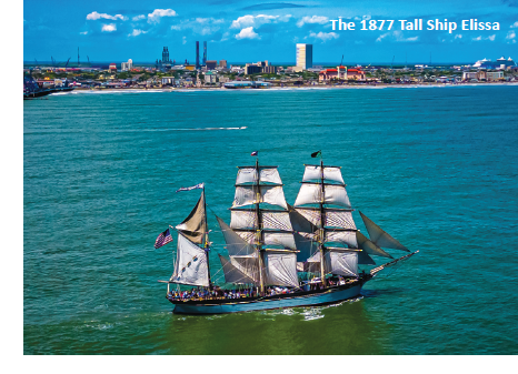
Another favorite of his is Galveston’s Parade of Sail, part
of the three-day “Tall Ships Challenge,” an annual series of
tall ship races and maritime port festivals in April that rotate
among the Atlantic Coast, Great Lakes, Pacific Coast and
now the Gulf Coast.
The event typically involves the gathering of tall ships,
which are large sailing vessels with multiple masts and
traditionally rigged sails. These ships often harken back to
the era of sailing ships and are known for their majestic
appearance and historical significance.
“It was a perfect day, everything was great. My pics turned
out wonderful, everything just worked out so well that day.
I was flying over the Gulf getting awesome pictures of tall
ships while standing shin deep in the water; a perfect island
moment for me.”
But the highlight, he said, was finding out that Captain Jan
Miles, senior captain of the legendary Pride of Baltimore II -
who in 2013 was recognized with the Lifetime Achievement
Award by Tall Ships America - used one of Grimes’ photos
for his personal blog, The Old Salt Blog.
“It really felt like a cool moment.”
As an FAA-certified drone pilot, Grimes has a better shot at
being granted access to controlled airspace - which includes
areas where air traffic control services are provided - at or
below 400 feet above ground level, or AGL.
“Normally, anything within five miles of an airport is a big
no-no yet having a Part 107 gives me more leeway with
gaining access to fly in those areas through the LAANC
system (Low Altitude Authorization and Notification
Capability).”
The primary constraint on the island is the five-mile radius
surrounding Scholes International Airport at Galveston.
Initially established as Galveston Municipal Airport in
1931 and officially dedicated on May 14, 1932, the airfield
underwent expansion in 1942 to serve the U.S. Army during
World War II . After three years, the federal government
deactivated the airport and handed it over to the City of
Galveston.
Designated by the FAA as a General Aviation Reliever
Airport, Scholes International Airport now accommodates
various activities, including private aviation, corporate travel, and air taxi operations.
“On an island this small, five miles takes up a lot of the
main parts of the city. Basically, Galveston Island Historic
Pleasure Pier is the eastern border of the controlled
airspace, and Spanish Grant Beach Neighborhood is the
western border,” he said.
“Everything in between is mostly zero-foot altitudecontrolled
airspace - which means there is no flight allowed
higher than zero feet off the ground.”
It’s imperative - and beneficial to everyone - that drone
operators have a working knowledge about things like
airspace, how weather affects the flight, how manned
aircraft takeoff and land at an airport, etcetera, he said.
“It really helps understand that there is a whole lot more
than you think going on up there, and it makes for a much
safer drone pilot.”
In addition to airspace restrictions, the island features a
multitude of helipads, and helicopters frequently operate
at low altitudes. Although not explicitly classified as
limitations, these factors should be taken into consideration,
he said.
Additionally, there are specific areas on the island that are
restricted, including the U.S. Coast Guard base, correctional
facilities, and “unfortunately,” the ports.
“I say unfortunately, because that limits some of the ability
to fly around the docked cruise ships - though as long as you
stay over the water, it’s okay. Other than the area around
the airport and the various restricted areas, the island is in
uncontrolled airspace.”
Though he has no prior experience in photography, Grimes’
combination of technical skills, attention to detail, patience,
and creativity contribute to his ability to capture wellcomposed
photographic pictures. These skills, when applied
to the art of photography, result in compelling and visually
engaging images, a discovery he had not expected.
“I remember the first time I posted some drone pictures in one of the drone groups I was in, and I asked their opinion, ecause I was new, and this was the first time I’d ever
posted anything and the response was ‘you may be new to
drones, but you definitely have a photography background,’
which I absolutely did not,” he said.
 “Things like that are encouraging, and, honestly, they
push me to try harder, so I have just kept moving forward,
learning new things and trying them out, if I mess it up, it’s
‘oh well just try again.’ This is not my job; I am having fun,
and I will keep it that way.”
“Things like that are encouraging, and, honestly, they
push me to try harder, so I have just kept moving forward,
learning new things and trying them out, if I mess it up, it’s
‘oh well just try again.’ This is not my job; I am having fun,
and I will keep it that way.”
His inherent interest and in-depth research into the world
of aerial photography has yielded positive results, and his
videos have captured a lot of attention.
“As I started getting more confidence in flying my drone
and editing the photos and videos, I would randomly post
them to different social media sites, but not anything that I
could tell people to follow or find me,” he said.
“So, I started a Facebook page, and I started sharing, and
I think it was the best thing I could have done; it has really
pushed me to learn more, get better, try more, and with it
came new questions like, ‘Do you do roof inspections? Do
you do real estate? Can I buy that picture?’”
With his FAA certification, the sky’s the limit.
The spirit of collaboration is another common thread
linking his two seemingly distinct interests. Microbiologists
join forces with experts in biochemistry, genetics, and
ecology, creating a symphony of disciplines to gain a
comprehensive understanding of microorganisms.
In the world of drone photography, collaboration extends
its reach, as hobbyists and professionals share their
knowledge and expertise.
“I have to say there is a really great community out there,
with so many people involved in every facet of drones,
and all of them are always willing to help out. The island is
full of amazing photographers. I am very much a novice in
comparison,” he said.
“We have an amazing community here on the island and
a growing group of photographers are utilizing drones and
their many years of experience to show off the absolute
beauty of the island and build excitement and hype
for the island. People like Toby Dawson (Toby Dawson
Photography), David James (Heavy Haul Photography), and
Waters Edge Digital Photography (Stephen Thompson and
Nikki Andrus) are out there finding new places to fly and
getting great unique shots of the island.”
Similar to the realm of scientific exploration, progress and
advancements occur as individuals build upon the work of
their colleagues, leveraging each other’s contributions to
achieve remarkable heights.
“Because of them and many others, we can build off each
other and continue to grow and get better with each and
every shot,” Grimes said. “At the end of the day, the island
wins.”
To see more of Michael Grimes’ drone photography, visit his
Facebook page, 409 Dronegraphy